Tuesday 6 November 2012

COMMUNITY FORUM A GREAT SUCCESS!

We would just like to take a moment to thank the 50+ people who made it out to the Community Forum last night. A lot of great discussion was had and some good ideas were put forth. Let's keep this momentum going and continue to watch those pipes!

For those who missed the meeting, here are some materials of interest:

Pipewatch Mid-Term Results Report 

Pipewatch Community Forum Presentation 

Hamilton Spectator Covers Pipewatch Community Forum


To view complete article, visit: 

Thursday 18 October 2012

From a Volunteer Pipewatcher


On October 11th I set off for the first time into Valley Park with my PipeWatcher Resident Handbook, which helpfully outlines how to identify problem outfalls and gives a map of the discharge points in Valley Park.  I was ready to see if there were any flows, smells or materials coming from any of the pipes.  There had only been 2.2mm of rain within the few days before the 11th, so I knew that there shouldn’t be any water, let alone sewage, coming out of the pipes (all of the discharges in Valley Park are storm sewer outfalls).

I started out with one of the concerning outfalls: DCT 32, at 10:20am.  There was only a slight odor- I don’t know how much stronger it would be if there wasn’t a significant wind and my nostrils were clear.  There was steady low flow coming from the pipe as well, which spread out into an algae-covered surface before going into the creek.  There was also some debris caught in the pipe grate and in the surrounding area.

Pipes DCT 31 – DCT 25 were fairly non-concerning, providing I could find them or see them well enough.  There was a bit of debris in the grate for DCT 27, but I couldn’t tell if it was materials that would have been flushed down the toilet.

It was somewhat difficult to locate pipes DCT 24 – DCT 21; I believe I found 22 and 24.  DCT 24 had a very slight odor, debris (mainly garbage) surrounding pipe, and a steady low flow of water.  The other only had a slight trickle of water, and there was a small amount of debris around the pipe.

Submitted by: Kirsten Gellein 


Monday 15 October 2012

October Workshops Recap

With a focus on both the Rosedale and McQuesten area, October's workshops provided residents with another opportunity to learn about the outfalls in their area, specifically RHC-27 and RHC-16. 

While both outfalls have several differences, which include location, appearance, and type (RHC-27 is a combined sewer outfall while RHC-16 is a storm outfall), they both unfortunately shared one common characteristic... green algae, and lots of it. 

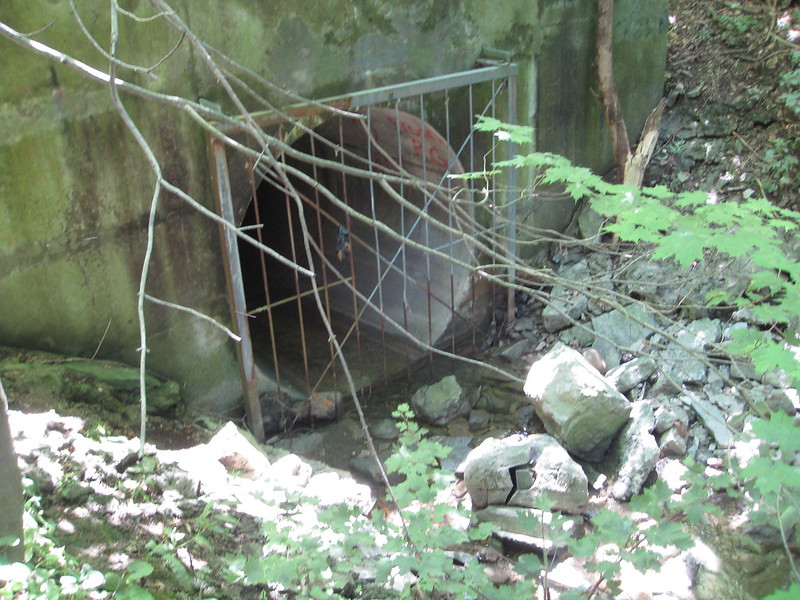
The picture below is of RHC-27, located in Rosedale Park beside the Bocce Ball facility. While this picture was taken back in July (it was too dark the night of the workshop to get a good shot), it depicts the same sight that was seen on October 10th. 

This picture is of RHC-16 and was taken Oct 9, 2012 by one of our volunteers. While this outfall raised initial concern due to the extensive garbage buildup in its grate (see previous post), this newly found mass pool of algae raised some eyebrows. 

In addition to noticing these pools of green, workshop participants also noted the following: 

RHC-27 : Pipe was flowing, with minimal smell, and minimal sanitary debris. 
RHC- 16 : Pipe was not flowing, had no smell, and had no sanitary debris. 

"Ah, there's nothing like rising with the sun to take a peaceful dip in your own pool." 
{Dives In} "Lisa! The blob has got me! Don't touch me or he'll get you too!" 

Tuesday 2 October 2012

OCTOBER WORKSHOPS ANNOUNCED!

A second mini-round of workshops has been announced! Click the poster for a closer look. All are welcome to attend. 


Sunday 23 September 2012

Rained Out!

With excess rain the night before making for some very muddy conditions, September 22nd's workshop in Rosedale was cancelled. Keep an eye out as we try to re-schedule! 

Thursday 20 September 2012

Last Night's Workshop: The Recap

Well, the grate was clean, but too bad the same can't be said for the water. The picture below shows RHC-16, the large outfall located at the corner of Barton Street E and Nash Road N. The picture on the left was taken earlier on this summer, and the picture on the right was taken last night. As you can hopefully tell, the grate is currently clean. In fact, there was practically no debris found at the site. Additionally, the pipe wasn't flowing, and there was no smell. The complete opposite of what was found back in July! 


 While the outfall wasn't exhibiting the 3 actions we ask Pipewatchers to look for, it was easy to tell from the water alone that this outfall still has issues. Check out the photo below. Would you swim in that? Would you let your kids?


Historically, this outfall has not only had visual issues, but confirmed contamination issues as well. In 2002, the city reported it to have 338,000 counts of E.coli, which is far above the bylaw limit of 2,400 (/100mL), and leaps and bounds over the Province of Ontario's Recreational Limit of 100 (/100mL). 


The next, and last, Pipewatch workshop of the month is scheduled for this Saturday, the 22nd, at 11:00am. We'll be meeting in the Rosedale Park area just outside of the Bocce Ball Facility. An informative stroll within a beautiful setting? I think that sounds like a great way to start your weekend! 

Monday 17 September 2012

Last Saturday's Workshop: The Recap

This past Saturday Pipewatch held its second workshop in the Quigley/Greenhill area. Taking the same route that was trekked a few days earlier, a new batch of volunteers were trained to identify outfalls within the area. Here's what we found: 


This is DCT-16. It's located about 50m north of Greenhill Avenue, just west of the large condo complex at the Quigley and Greenhill intersection. In 2002, it was recorded as having E.coli counts of 338,000 (/100ml) - which far exceeds the city by-law limit of 2,400 counts (/100ml), and the province's recreational limit of 1000 counts (/100ml). 

Here's a closer look:


Gross, right? While there was no strong odor, it's clear that the pipe was flowing and had a lot of debris built up on the grate. Volunteers (at both workshops) also noted dark algae at the base of the outfall. Algae (in these conditions) is bad as it helps to remove oxygen from the water supply leaving harsher living conditions for the creek critters and small invertebrates that reside along the creek bed. 

This section of the creek is also home to another outfall, DCT-15, which is located directly beneath the lookout for DCT-16. For a pipewatcher short on time, this location is ideal! 
While DCT-15's discharges have historically been recorded as less concerning than DCT-16's, the total counts of E.coli were above the levels set by both the Hamilton by-law and the province of Ontario. On June 5, 2002 it was recorded to have 27,000 counts (/100ml). On Saturday, the pipe was discharging, there was only a slight smell, and as you can see, there is some debris on the grate. 

The view looking down. 


The view from the other side of the creek (on top of DCT-16). 


Couldn't make either one of the two sessions in this neighbourhood? Don't worry, you haven't missed the boat! Call us up if you're interested (905-549-0900) and we will be more than happy to arrange a time to meet and show you the outfalls in the area. 

Otherwise, the next workshop will take place on Wednesday, September 19th, at 6:30pm. We'll be meeting at the corner of Melvin and Talbot Street (in the McQuesten community). Bring your walking shoes as we'll be walking along some of the Red Hill Trail, crossing the highway (along the sidewalk of course!), and hopping the guardrail to view one of the worst outfall offenders - it should be a doozy! 

Thursday 13 September 2012

Last Night's Workshop : The Recap

Last night volunteers met at the corner of Quigley and Greenhill to learn about and monitor the 6 discharge points within their area. Together we walked the stretch of creek behind the large condo complex, crossed Quigley road, and headed along trail behind Veevers Drive. Here are some of our findings:


Above is DCT -11, a storm sewer outfall located at the end of the trail behind Marcella Cresent. In preparation for this workshop, this outfall was also visited on Tuesday, September 11th at 11am. At this time not only was the pipe discharging, but there was also a fowl odor that could be smelled at least 10m away. Last night however, while the pipe was still discharging, the smell was gone - lucky for our volunteers! 

In addition to others in the area, this pipe in particular has been on EH's radar for quite some time. Back in 2002 when the MOE ordered the city to collect samples from discharges of concern, 4 samples were taken from this outfall; 2 during dry conditions, 1 during low rain conditions (1 to 7mm of rain), and 1 during medium wet conditions (8 to 18mm of rain). All of these samples contained E.coli counts which exceeded the city by-law limit of 2,400 counts (/100ml). In fact, a sample taken during a dry spell on July 8th was recorded to have 480,000 counts!  For that reason, and for the fact that it continues to release discharges and odors, we plan to keep a close eye on it! 

Volunteers also recorded the following: 

DCT - 16 : Medium levels of debris built up in the grate. No flow. No smell. 
DCT - 15: Medium levels of debris built up in the grate. Low flow. No smell. 
DCT - 14 and 13: Couldn't be seen by volunteers (requires going into the culvert).
DCT - 12: Couldn't be seen by volunteers (requires going into and crossing the creek).

In case you missed last night's workshop, we'll be holding an identical session this Saturday at 11am! So strap on your walking shoes, put on a bit of bug repellent, and we'll see you at the corner of Quigley and Greenhill! 


Tuesday 11 September 2012

City Invests Into Wellington CSO

In case you missed the article in the Spectator today, the city of Hamilton is set to install a $4 million real-time control system to better manage the combined sewage that is currently flowing from the Wellington CSO.

This pipe alone is responsible for annually releasing approximately 340,000 cubic meters of untreated sewage into the bay - that's one third of the storm-fuelled sewage that spills directly into the harbor!

Click here to read the full article. 

Photo credit: Michael Cook/Hamilton Spectator 
The Wellington Street combined sewer overflow is dark and dank in this view looking downstream toward the harbour.

Tuesday 28 August 2012

IT'S TIME TO BE A PIPEWATCHER!

Over the past few weeks we’ve trekking through the creek, identifying problem outfalls, and compiling our materials. Now we’re ready for you!

Are you looking to get outside this fall? Learn about your watershed and the impacts we as Hamiltonians are having on it? Looking to make a difference and help improve the creek’s health? Great! You have the makings of a Pipewatcher!

Join us at one or more of FREE workshops taking place this September. Within one hour we’ll have you identifying the combined sewer and storm outfalls within your area, monitoring them to identify problem discharges, and feeling empowered to report concerns to the appropriate channels. To register, please contact Katie at the Environment Hamilton office (905-549-0900).

Area 1: Valley Park (Meet outside the Valley Park Library) 
Wed. Sept 5 @ 6:30pm & Sat. Sept 8 @ 11:00am


Area 2: Greenhill (Meet at the corner of Greenhill + Quigley Rd)
Wed. Sept. 12 @ 6:30pm & Sat. Sept. 15 @ 11:00am 

Area 3: McQuesten (Meet at the corner of Melvin + Talbot St.)
Wed. Sept. 19 @ 6:30pm 


Area 4: Rosedale (Meet outside the Bocce Ball Club)
Sat. Sept. 22 @ 11:00am

Tuesday 21 August 2012

Keep the Sediment Out!


Does this look concerning to you? It does to us. The picture was taken on August 13th, 2012 at the corner of Kentley and Nugent, the current worksite of FER-PAL, a construction company specializing in water main restoration. 

Not only was this sediment being tracked down Kently by passing cars, but it was flowing into the city's storm sewers - which bypass the waste water treatment plant and flow directly into the watershed. 

Remembering the effort the city put into reducing excess sediment from flowing into the sewers during the Red Hill construction, Environment Hamilton asked Councillor Collins (in additon to sending him this picture) whether the city required contractors to take specific measures to minimalize sediment flow into the sewer system. 

Chad forwarded our concern to Public Works who confirmed that contractors "are required to have filtration cloth on all catchbasins prior to work commencing". They then made the assurance that all catch basins in the area would equipped with the filtration cloth and inspection staff will follow up with the concern. 

The result? Check out the image below. 


Friday 17 August 2012

How Many Can You Spot??

This morning Pipewatch headed down to Davis Creek (the section just south of the Quigley Rd and Greenhill Ave intersection) to do a practice benthic macroinvertebrate monitoring session. 

What are benthic macroinvertebrates you ask? Great question! Benthic macroinvertebrates, or creek critters as they’re commonly known, are “relatively sedentary organisms that inhabit or depend upon the sedimentary environment for their various life functions. Therefore, they are sensitive to both long-term and short-term changes in habitat, sediment, and water quality.”

Since they are so sensitive  to changes in the creek bed/water, monitoring them is an effective way to track a creek’s health over time. 
Keep an eye out for Creek Critter monitoring workshops coming this fall! Here we'll be teaching students and residents how to identify these organisms so that they can determine the health of their neighboring watershed. 
In the meantime, how many sowbugs can you see in this sample? 


Tuesday 7 August 2012

Did You Hear About the Floodplains and the Flood Hot Spots?

In case you missed it, the Spectator has recently reported about the City's plans to remap the creek floodplain and digitally map Hamilton's flooding hot spots. Check out the articles below to learn more!  

A Wave of Concern About New Area Maps (August 2, 2012)

The conservation authority will remap the floodplain of creeks across Hamilton, an exercise that could have implications for existing homes and new development across the city.
The $500,000 project is expected to take at least five years and will re-examine flood lines — the flooding high-water mark during major storms — for Hamilton’s creeks and smaller tributaries, including Red Hill, Battlefield and Spencer.

To read more, please click here.

City to Make Map Flooding Hot Spots (August 3, 2012) 

The city is digitally mapping about 900 flooding “hot spots” across the city that crews inspect in advance of a big storm. The city is assigning GIS co-ordinates for each hot spot to allow for easier tracking and trend-spotting, but the map won’t be available to the public online.

To read more, please click here

Wednesday 1 August 2012

When It Rains, It Pours... And Floods

While all Hamiltoanians have experienced the recent storm events in some capacity, certain neighborhoods are really feeling the impacts. 

One area in particular is Greenhill Avenue just west of Quigley Rd, which we came across on July 27th while searching for outfalls in the area. It was clear that not only a major storm event had taken place, but extensive flooding had occurred as well. Check out the picture below. Can you see the mud on the road and on the curb? This led us to believe that the creek rose to the point where it flowed over the culvert and across the street - which is very high! 

We later spoke to residents within the area who confirmed the flooding. According to them, the  heavy rain events on July 22nd caused boulders within the creek to be washed downstream -- which resulted in extensive area flooding, uprooting of trees which bordered the creek bed, and high volumes of mud. Needless to say the city had a large cleanup job on their hands! 

In addition to the roadway being a clear indicator of high water levels, the creek bank itself was also very telling. Check out the picture below, which was taken at a stretch of Davis Creek just north of Mud Rd. Notice how the lower shrubbery is all folded over in the direction of the current? This shows us how high the water level rose in the Valley Park area and how powerful the current was. 


All Plugged Up and Nowhere to Go


This shot was taken on July 10th at the huge storm sewer outfall along the Red Hill expressway near Barton St. In addition to the fowl odor and murky waters which surrounded the area, the obvious build up within the grate showed a cause for concern!


Why are blocked outfall pipes a concern you ask? Let's consider Hamilton's sewer system - which consists of two types of outfalls. 


Combined Sewer Outfalls

Currently, the older portions of the city's sewer system collects both domestic sewage (from sink drains and toilets) and storm water runoff in a single pipe called a combined sewer.  This mixture, called combined sewage, is then sent to the Woodward Avenue Wastewater Treatment Plant (WWTP) for treatment. During dry weather or small rainstorms, all combined sewage receives full treatment before it is discharged to Hamilton Harbour. 

During heavy rainstorms however, the excess water can cause excess combined sewage that the sewer system can’t handle. To address this problem, the city has 6 Combined Sewer Overflow Tanks. These tanks store the excess combined sewage during rainstorms. The tanks are filled by gravity, and when flows subside after a rainstorm, their liquid contents are drained or pumped back into the combined sewer system and conveyed to the Woodward Avenue WWTP where they are treated.

In some cases, the rainfall will be so heavy that the system and the tanks become overloaded as well. When this happens, the excess wastewater will be discharged directly into Hamilton’s natural waterways (at either Hamilton Harbour, Cootes Paradise, Chedoke Creek, or the Red Hill Creek). These discharge points are called Combined Sewer Overflows (CSO).

Storm Sewer Outfalls 

The storm sewers located on our roadways and in front of our properties are meant for storm water runoff only — as the materials that go down these drains filter directly into our natural waterways. These discharge points are referred to as storm outfalls. 


Given their nature, these two types of discharge points should only be flowing if there is excess combined sewage or excess road water. If these outfalls become plugged or backed up (like the grate on this outfall), the water and combined sewage within the overloaded system will need to find another release point. Say, residential basements? 

To address this outfall a picture was sent to Ward Councillors Merulla and Collins. They sent it on to the City Manager and Public Works staff who cleaned out the grate by the next morning. The city said it was unsure as to why their protocol to visit 'priority outfalls' pre- and post- storm events was not followed. 

Unfortunately, upon more recent visits, it appears that the debris on the grate is already beginning to accumulate again. So let's keep an eye out on this one!  

*Information from this post was taken from the City of Hamilton's website. 


Tuesday 31 July 2012

Pipewatch is Back! ... But Why?


In December of 2001, the Ministry of Environment’s Hamilton District Office issued an order requiring the city of Hamilton to analyse the discharge from every outfall into the Red Hill Creek watershed after investigating a series of citizen complaints regarding problem discharges. These discharges consisted of fecal matter and sanitary debris coming from storm sewer and combined sewer outfall pipes. During periods between major storm events, these outfalls should not have been discharging contaminants to local waterways.

The MOE also ordered that the city propose and implement resolutions to any problem discharges identified. The city failed to do this by the set deadline and additionally failed to request an extension. This resulted in the referral of the case to the MOE’s Investigation and Enforcement Branch.

At that time, Environment Hamilton conducted sampling work during drought conditions to determine whether the sewer outfalls were functioning properly. Our sampling confirmed that all of these discharge points except for one had bacterial contamination beyond allowable levels for recreational use of a waterway. Discharges were as high as 160 times above allowable levels for E. coli. We found these levels at a storm sewer outfall bearing no warning sign to the public of this contamination hazard.

Anticipating that these outfall issues remain a concern, Environment Hamilton is reviving its Pipewatch Program. Our goal is to revisit the concerns raised by neighbourhing residents and revisit the discharge issues known to exist within the Red Hill Creek watershed. We aim to determine whether the health of the creek has improved since the widespread problems were identified over a decade ago.  

To do this, residents and students will be empowered with the skills needed to properly identify pipe discharge points as either storm or combined sewer outfalls, and to properly monitor these outfalls for potential discharge problems using basic visual observations and sense of smell.  It is our hope that with increased responsibility and ownership of the watershed, we can better hold polluters accountable – helping to ensure that the watershed is enhanced and protected over time.

At this point the program is in its early stages. However, volunteers are welcome and encouraged to get involved! If you are interested in helping to monitor the watershed within the upcoming weeks and months, please contact Katie atkstiel@environmenthamilton.org. Also be sure to keep an eye out for our first community training session!